|
Information on this page comes from
(Print the map and directions to popular birding places
- Part One -
Part Two) |
||||
|
 ● Auto/Walking Tours ● Public Access to Utah Lake ● Popular Birding Sites ● Other Popular Birding Sites |
||||
|
|
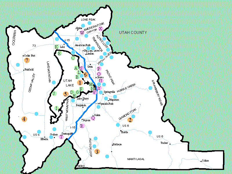
Map of Birding Sites | Auto/Walking Tours | Access to Utah Lake | Popular Birding Sites |
1. Provo Airport Dike
Tour Time:
2-3 hours, Distance: 5 miles, Road:
bumpy dirt road, Elev.: 4497 FT,
No. Species: 30-40
2. Diamond Fork Canyon - Auto Tour
Tour Time:
2-3 hours, Distance: 35-40 miles,
Road: paved but narrow, Elev.:
5100 FT, No. Species: 30-40
3. Payson Lakes - (Nebo Loop) Auto Tour
Tour Time:
3-4 hours, Distance: 80 miles,
Road: paved but narrow,
Elev.: 5500-7500 FT, No. Species:
15-25
4. Broad Canyon - Auto Tour
Habitat:
sagebrush, Pinyon Juniper
Tour Time:
6-8 hours, Distance: 125 miles,
Road: graded dirt to rough & rocky
- 4x4, Elev.: 4518 - 7428 FT,
No. Species:
20-30
5. Lincoln Point & West Mountain -
Auto Tour
Habitat: farm land , marshes, lakeshore
Tour Time:
4-5 hours, Distance: 45 miles,
Road: majority paved, some dirt,
Elev.: 4500 FT, No.
Species:
40-50
6. Lower Provo River Parkway - Walking Tour
Habitat:
riparian, farm land, marshes, lakeshore
Distance:
2 1/2 miles, Road: graded, level
walking path, Elev.: 4500 FT,
No. Species:
25-30
7. Cedar
Valley - Auto Tour Habitat:
dry farm land, grassland, Pinyon-juniper forest
Tour Time:
4 hours, Distance: 45 miles,
Road: majority paved, some dirt,
Elev.: 4600 FT, No. Species:
25-30
● Public Access to Utah Lake: Public
Marinas and Boat Launches
|
Map of Birding Sites | Auto/Walking Tours | Access to Utah Lake | Popular Birding Sites |
(To print the map and directions to popular birding places go to the Print Center)
A. Lindon Marina
B. Utah Lake State Park C. American Fork Marina D. Lincoln Point/Lincoln Beach E. Jordan River / Inlet ParkSportsman Accesses to Utah Lake and marshes
Sportsman Accesses to Utah Lake are provided by the Utah State Division of Wildlife
Resources (DWR) for hunters and
fishermen to gain access to the shore areas. They normally
consist of a right-of-way and a parking area.
● Popular Birding Sites
|
Map of Birding Sites | Auto/Walking Tours | Access to Utah Lake | Popular Birding Sites |
O. BYU Botany Pond (N 40º 14.675' W 111º 39.039')
P. Rock Canyon (N 40º 15.875' W 111º 37.805')
Q. Salem Pond (N 40º 02.996' W 111º 40.454')
R. Spring Lake (N 40º 00.218' W 111º 44.760')
S. Geneva Cooling Ponds (N 40º 19.629' W 111º 45.799')
T. Warm Springs Wildlife Management Area (N 39º 57.793' W 111º 51.272')
U. Provo City Cemetery (N 40º 13.500 W 111º 38.614')
V. Camelot Woods (N 40º 11.308' W 111º 38.978')
W. American Fork Canyon (Alpine Loop) (N 40º 25.950' W 111º 45.080')
X. Timpooneke (N 40º 25.976' W 111º 38.166')
Y. Provo Wetlands Wildlife Protection Area (N 40º 11.842' W 111º 38.355')
●
(Other
Popular Birding Sites in
Utah County)
|
Map of Birding Sites | Auto/Walking Tours | Access to Utah Lake | Popular Birding Sites |
