|
Broad Canyon Auto Tour |
 |
|
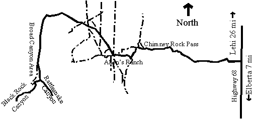
Submitted by Robin Tuck Description: Broad Canyon (see map above) is approximately 50 miles southwest of Provo. A word of caution: If the road has not been graded, the last few miles may be rough and rutted. Directions: To get to Broad Canyon, take I-l5 south to Santaquin, Exit 244, about 20 miles from Provo. Go 10 miles west to the Elberta/Highway 68 junction. Turn right and go north on the Utah Lake Road. Look for raptors along this highway. At about mile-mark 7, N 40 03.257' W 111 57.491' prior to a lone brown house west of the highway, turn left onto the county road which goes west. This road will eventually pass through a sparse juniper forest, with the possibility of Northern Mockingbirds, then on past a rock out-cropping, Chimney Rock, where there may be Rock Wrens. The road then goes onto the desert floor and by-passes the isolated Allen's Ranch, at N 40 03.413 W 112 04.888'. Antelope may be seen around the mountain to the west, also a variety of desert bird species, including Loggerhead Shrike, Sage Thrasher, Horned Lark, Mountain Bluebird, Say's Phoebe, Long-billed Curlew, and Common Nighthawk. l.2 miles northwest of Allen's Ranch there is a "Y" junction. Take the left fork, a lesser road, that goes to Broad Canyon. (The right fork goes about l5 miles straight north to Fairfield, a winter gathering place for Bald Eagles.) Watch for Pinyon Jays. Keep left for about 4 miles up Broad Canyon where scrub oak and pinyon/juniper are habitat for Black-throated Gray Warbler, Mountain Chickadee, Plain Titmouse, and Clark's Nutcracker. The next "Y" junction at N 40 03.690' W 112 09.130' leads to two lesser canyons. The left fork goes to Rattlesnake Canyon, with a small inviting wildlife watering pool located one-tenth mile from the "Y". This road dead-ends. The right fork goes to Black Rock Canyon, which has a grassy area at 2.3 miles from the junction. As the elevation increases, the road becomes narrow, rough and rocky, with dense vegetation. This road traverses the Utah County/Tooele County boundary below the ridge/saddle of Tintic Mountain. Bushtits occur in this area. The road goes over the top of Tintic Mountain and connects with Highway 36, about 5 miles northwest of Tintic Junction. For the return trip, either go left at the junction east of Allen's Ranch and retrace the journey back to Highway 68 or go right (south) over the mountain to Highway 6 east of Eureka., about 7 miles. eBird Data: | Chimney Rock Pass | Homansville Pass Road | Nearby: |
Tintic Loop |
Elberta Slant Road | Chimney Rock Pass |
|
|
|